Story
Superyacht Science: How luxury boat owners are supporting global marine research
16 February 2024
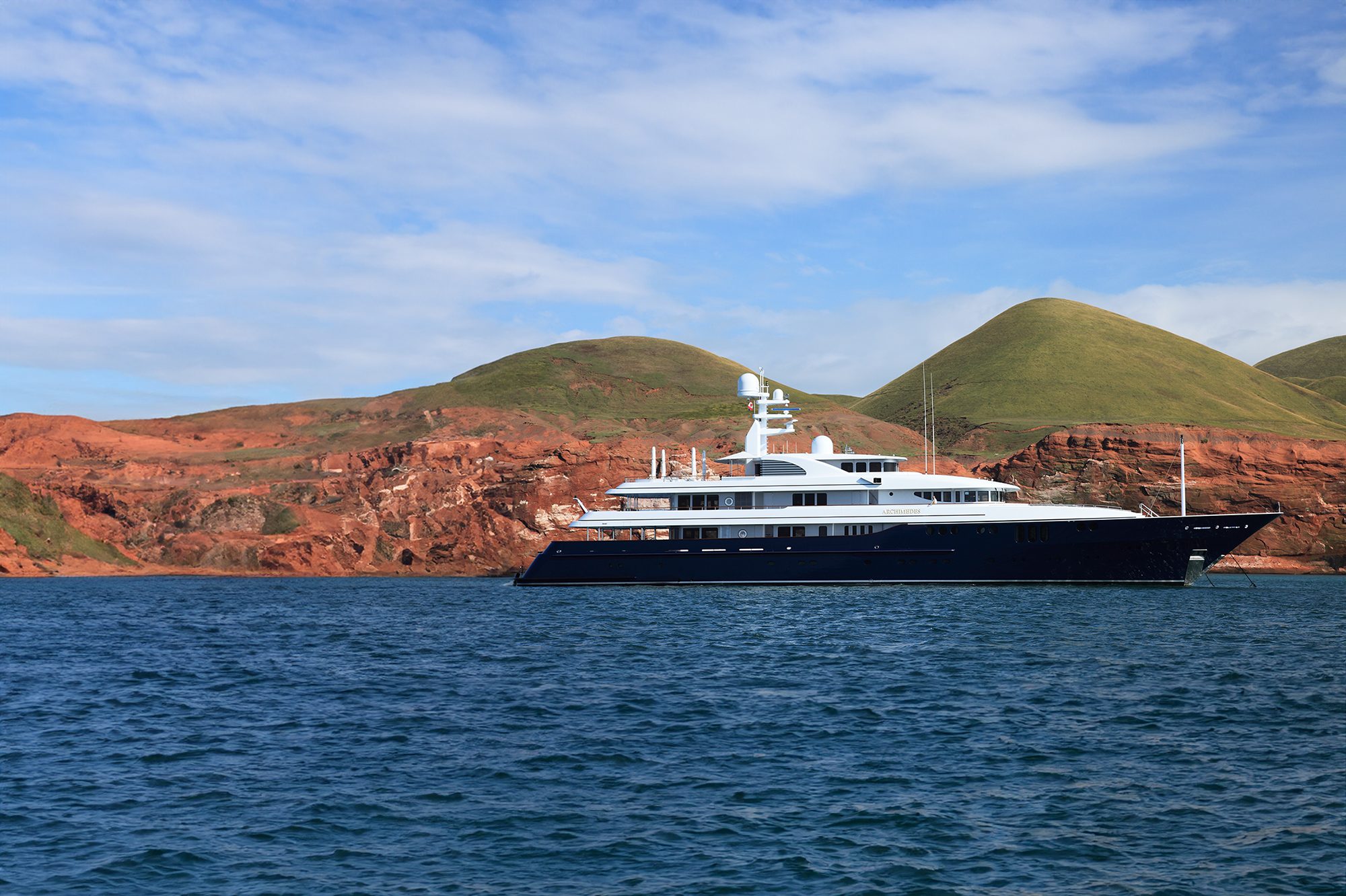
In their quest to improve our understanding of the changes taking place in the world’s oceans, leading scientists from Plymouth Marine Laboratory and the University of Exeter have found new allies in the form of superyacht owners and philanthropists Jim and Marilyn Simons (co-founders of the Simons Foundation), who are using their 68-meter superyacht – the Archimedes – to support marine research in some of the most remote and least studied parts of the ocean.
Dr Shubha Sathyendranath of Plymouth Marine Laboratory and Dr Robert Brewin of the University of Exeter are world-leading experts in the use of satellites to observe the colour of the ocean. Satellites are a hugely powerful tool in marine research, enabling observations over vast areas of the ocean and revealing what is taking place under the waves. Satellite observations of ocean colour (light in the visible part of the spectrum) enable us to observe phytoplankton (the microscopic algae that make up the base of the marine food web), which, in turn, reveals crucial information about rates of carbon capture by the ocean (via photosynthesis by phytoplankton), the location of harmful algal blooms, the location of productive ecosystems and fisheries, and information about marine biodiversity. Such information is vital to understanding climate change and to managing the marine and coastal environment, particularly in industries such as fisheries, aquaculture and tourism, and in biodiversity conservation.
Monitoring the world’s oceans is no easy task, however, even with satellites. One major challenge is that less than 10% of the light detected by satellite instruments originates from the ocean – the vast majority comes from the atmosphere and glint from the surface of the water. Scientists can correct for this interference but to develop the methods to do so, they need to simultaneously collect data via satellite and at the water surface at representative locations around the globe. This is where the Archimedes comes in.
With the Simons’ support, a hyperspectral radiometer (an instrument measuring light at various wavelengths) has been mounted on the bow of the Archimedes, enabling the collection of in-situ data to compare with satellite data on ocean colour. Using the data from the Archimedes, Brewin and Sathyendranath can develop and fine-tune algorithms that they apply to raw satellite data to correct for atmospheric interference and surface glint, thereby revealing the true picture of ocean colour, and also refine algorithms that are designed to infer from the measured light the substances that were responsible for changing the light field.
Dr Shubha Sathyendranath, Merit Remote Sensing Scientist at Plymouth Marine Laboratory, said:
“We’re extremely excited by this collaboration and the information it can help uncover about our changing ocean. The Archimedes travels to parts of the ocean that are rarely sampled – such as remote areas of the Atlantic, Pacific and Southern Oceans – so the information it gives us is incredibly valuable. We’re very grateful to the Simons for being part of the project. I feel this is a great model for how boat-owners and scientists can work together to enable a better understanding of the marine environment”.
Dr Bob Brewin, Senior Lecturer in Physical Geography at the University of Exeter &UKRI Future Leader Fellow, said:
“Having high-quality in-situ data is vital to the accuracy and credibility of the learnings we can gain from satellite ocean colour data. Given the limited resources available for research vessels and the vast areas we need to cover, it is a huge advantage to be able to use a vessel like the Archimedes to support our studies”.
Jim Simons and Marilyn Simons co-founded the Simons Foundation in 1994 to advance the frontiers of mathematics and the basic sciences, and commented:
“We are very happy to help with pioneering work in ocean colour monitoring by lending the Archimedes. The project will help answer key questions about the ocean, we hope. It will help to discover sustainable approaches to management of our marine ecosystems and resources”.
Results and recommendations from the Archimedes pilot study
The Archimedes reflectance dataset compared well with data from the MODIS-Aqua satellite sensor at the six wavelengths studied, and statistical metrics obtained in the validation exercise using Archimedes were in good agreement with those using other data collected by scientists.
These results demonstrate that automated data collection on superyachts can provide very useful data for the validation of satellite ocean colour measurements. When considering that superyachts visit remote regions, in the case of Archimedes regions such as the Antarctic peninsula, this may help provide quality in-situ radiometric observations in regions rarely sampled.
With increasing numbers of ocean-colour satellites being launched, investments in sustaining ocean colour data over time, and new hyperspectral ocean-colour satellites, it is critical that the international Earth observation community continues investing in the collection of in-situ reflectance data and explore new ways to expand the coverage of these datasets. Augmenting superyachts with ocean colour radiometers could be one opportunity to do this.
For this strategy to be successful, certain challenges need to be considered:
- The scientific community needs to find ways to engage with superyacht communities, to highlight the value and benefits of collecting in-situ data. Scientists should consider ways in which they could motivate superyacht owners to collect in-situ data, building on citizen-science based principles and existing initiatives, such as Yachts for Science, promoting financial investment that adds to existing funding for validation. Satellite validation work could also extend beyond ocean colour data, for example, collecting sea surface temperature data for validation of satellite thermal radiometers, by utilising state-of-the-art in-situ methods.
- Availability of appropriate equipment is a potential issue for ocean colour validation on superyachts. Unfortunately, a few years after the Sea-Bird Scientific SAS Solar Tracker Aiming unit was purchased for Archimedes, the manufacturer decommissioned the system. However, similar systems are now being developed, for example, the EU-funded MONOCLE project saw the development of a Solar-tracking Radiometry platform (So-Rad) system, designed to be operated with commercial radiometers with a high degree of automation and low-power consumption. The So-Rad designs are open-source and the system can be installed on non-stationary platforms like superyachts.
- It is essential there is a good relationship and close dialog between the crew of the superyacht and scientists to ensure these systems are set-up appropriately, and for support during operation. This was key to the success of the pilot study on the Archimedes yacht.
- Options for data transfer requires further exploration. For the pilot study on the Archimedes yacht, data were periodically transferred via File Transfer Protocol (FTP). This worked well but meant data were not processed in near real time. Adopting a near real time data transfer/upload system could be useful for operational applications and identifying any issues with the data that could be resolved quickly (both in-situ and satellite).
- Development of advanced processing software. The pilot study on the Archimedes yacht benefited from the development of HyperInSPACE software, allowing for the rapid processing of radiometric data, with full traceability. The software is also designed to ingest new developments in radiometric data processing, as and when they appear. Increasing efforts are being placed on quantifying uncertainties, that should be incorporated in the software in the future, bringing further rigor to the quality of the measurements.
- It is essential that appropriate data archiving systems are maintained and available to support initiatives like this. These need to be open source, to maximise data usage, and must be designed to cater for the raw radiometric measurements, the processed data, with full traceability between the two, so future reprocessing by other data users can be made. Additionally, these data should also be ingested into other archives or data compilations, to broaden the user community and allow for integration with other data streams.
Origin of the collaboration
This collaboration came about through the philanthropic work of the Simons, through their family foundation. The Simons Foundation supports advances in mathematics and basic, discovery-driven science. The Foundation is funding the CBIOMES project, which started in 2016 and aims to develop and apply computational models of marine microbial communities. As one of the lead scientists on the project, Dr Sathyendranath was invited to New York for a project meeting and met Jim Simons and Marion Carlson, the Simons Foundation Director for Life Sciences. Sathyendranath and Brewin offered to help with the Archimedes project, which had just been initiated by the Simons.
Value of ocean colour satellite observations
Observing ocean colour from satellites enables scientists to answer key questions about our ocean and provides information of immediate practical significance, for example:
- Through photosynthesis, phytoplankton take up enormous amounts of carbon dioxide, playing a vital role in regulating our climate. Ocean colour observations have revealed just how much photosynthesis is taking place in the ocean – about 50 Gt carbon per year, roughly equal to photosynthesis by all the world’s land plants once corrected for losses due to respiration, making this one of the largest fluxes of carbon on the planet. Important questions remain to be addressed though. For instance, we do not know with much certainty how the rate of photosynthesis in the global ocean will respond to climate change. It could increase, helping to put the brakes on climate change by soaking up more carbon dioxide, or it could decrease, accelerating climate change further. Currently, at 25 years, the continuous satellite ocean colour data record is too short to discern long-term climatic changes from natural variability. As the data record grows, we will be able to answer questions such as these.
- Studying how the timing of algal spring blooms is changing due to climate change is important because fish depend on these events for the survival of their larvae. The timing of larval hatching must correspond to the timing of algal growth so that the fish larvae have sufficient food. Over millions of years, evolution has selected fish that hatch at the optimal time. However, larval hatching and algal growth are triggered by different environmental cues and there is a high risk that as the climate changes, these cues could occur at different times, decreasing the survival of the fish larvae with potentially major consequences for the rest of the ecosystem and our fisheries.
- Ocean colour can tell us when and where harmful algal blooms and other environmental phenomena, such as coastal eutrophication (nutrient pollution) and sediment plumes, occur. Ocean colour data form the basis of early warning systems that forecast the risk of these phenomena and warn marine users such as aquaculture producers and tourism operators.
- Ocean colour can indicate where and when fisheries are likely to be productive. Since phytoplankton form the base of the food chain, the location of fisheries broadly maps onto the productivity of phytoplankton. Maps of phytoplankton, or more precisely chlorophyll distribution derived from satellite data, are used to predict where fisheries production is likely to be high and provide valuable information to fishers. The Indian National Centre for Ocean Information Services, for example, uses satellite-derived ocean colour and sea surface temperature data to generate maps of potential fishing zones that are shared with fishers to improve fishing efficiency. The bulletins also show zones where fishing is restricted to protect endangered species such as whale sharks and sea turtles. Research involving ocean colour could potentially predict future long-term changes to fisheries due to climate change, enabling countries and communities to plan ahead.
- Ocean colour can support biodiversity conservation. Many species of conservation importance are predators of fish and invertebrates whose distributions are closely tied to the distribution of phytoplankton. For example, cetaceans, seabirds, sharks and turtles concentrate in highly productive zones and around ocean fronts, the dynamic interfaces between bodies of seawater, all of which can be revealed by ocean colour. Satellite observations of ocean fronts conducted at Plymouth Marine Laboratory have helped to define the boundaries of marine protected areas spanning over 600,000 square kilometers around the UK and in the Pacific Ocean, helping to safeguard endangered species.
- In groundbreaking research, Dr Sathyendranath and colleagues have shown that ocean colour can even map the risk of cholera outbreaks. Transmission of this waterborne disease is strongly influenced by environmental factors linked to ocean colour. Sathyendranath and colleagues have developed algorithms that estimate disease risk based on ocean colour satellite data. This breakthrough could play an important role in the World Health Organisation’s plan to eradicate cholera by helping to improve disease detection and response systems.
Value of in-situ observations
In-situ observations are needed to validate satellite observations and are also valuable because satellite ocean colour instruments cannot “see’ through clouds. Clouds have a big effect on photosynthesis by phytoplankton (hence carbon sequestration, etc.) by modifying the light available in the sea, so it is important to understand what is taking place when the weather is cloudy.
The Archimedes goes to interesting places, including remote parts of the ocean that are rarely sampled. This makes it especially valuable for this kind of research since the algorithms that correct for atmospheric interference need to be tuned to regional conditions (e.g., regional differences in atmospheric aerosols). The Archimedes data will reduce uncertainties in satellite measurements in poorly sampled regions, including parts of the Indian Ocean, Pacific Ocean, and Southern Ocean.
The instruments
There are five instruments onboard. Three of them measure light – more specifically, radiance (light at a fixed angle) – coming from 45 degrees below and 45 degrees above the horizontal plane at specific wavelengths. The fourth instrument is a pyrometer. This measures the temperature at the very surface of the ocean by measuring infrared radiation emitted by the very top micron (one millionth of a meter), sometimes referred to as “the skin of the ocean”. Finally, a solar tracker orients the whole set of instruments at a certain orientation relative to the sun. The whole set-up weighs in at about 80 lbs and cost about $80,000.
Hyperspectral satellite missions
An exciting aspect of this work is that the radiometer on board the Archimedes is a hyperspectral instrument, meaning it measures light at many discrete and contiguous wavelengths. Until now, ocean colour satellites have typically measured light at 6-10 different wavelengths, whereas future missions will carry hyperspectral instruments that will provide a lot more information about the colour of the ocean and what is taking place below the surface. NASA’s upcoming PACE (Plankton, Aerosol, Cloud, ocean Ecosystem) satellite mission, due to launch late 2022, for example, will carry the Ocean Color Instrument, a hyperspectral radiometer that will measure 117 different bands: every 5 nm between 340 and 890 nm (ultraviolet to near-infrared), as well as seven discrete bands in the shortwave infrared.
Hyperspectral instruments such as this will enable us to observe much more detail about ocean ecosystems. They will enable us to observe different types of phytoplankton according to their characteristic colour “signatures” (determined by their photosynthetic and photo-protective pigments and light-scattering properties). This is important because different phytoplankton types have very different effects on the carbon cycle and marine ecosystems. Some cause carbon to be transported to the deep sea, locking it away for hundreds of years, whereas others don’t (because of their size, sinking velocity, place in the food web and other factors). Thus, they can have radically different effects on carbon sequestration and climate. Different phytoplankton types also support different predators, and the composition of the rest of the ecosystem can be determined by the phytoplankton. This is seen in Benguela, off the west coast of southern Africa, where there is evidence that when diatoms dominate the phytoplankton, the fish are dominated by herring, whereas when dinoflagellates dominate the phytoplankton, the dominant fish is sardine. Different phytoplankton types also respond differently to environmental change. The abundance of different types is changing in many parts of the ocean, and this will have consequences for climate, fisheries and biodiversity. Hyperspectral ocean colour satellite observations will enable us to observe, understand and map these changes, providing valuable information to help fishers, conservationists and others adapt.
Last year (2021), NASA developed an open source community code to derive ocean colour data from raw hyperspectral data. Bob Brewin collaborated with Dirk Aurin, a research scientist at NASA, to develop this code to process the data from the Archimedes.
Data
The data will be made publicly available to the research community via SeaBASS, a database maintained by NASA’s Ocean Biology Processing Group, and CMap, the Simons Foundation’s open-source data portal for oceanographic datasets.
The data collected by the crew of the Archimedes, headed by captain Christopher Walsh, are transmitted to Bob at his office in Exeter.
Vision for future collaborations
Sea-going vessels are a very valuable platform for scientific research and there are many studies we could do with further collaborations like this one. Various kinds of instruments can be mounted on vessels and operated largely autonomously (although participation of the captain and crew is also great). For example, they can be used to collect samples of marine life or pollutants such as microplastics. With the full participation of the crew, vessels can also be used to deploy and retrieve instruments such as Argo floats that provide vital data about the ocean state.
Related information
Full paper: Superyachts could support satellite ocean colour validation
